Marine Geo Surveys
What type of Marine Geo Survey do you require?
Diveworks International have the capability to provide a variety of marine surveys. Whether our clients need us to locate potential UXO threat or to provide imagery of a structure, Diveworks International can accommodate these needs. We deliver Marine Geo Surveys to meet these requirements.
A geophysical survey investigates and maps the earth within bodies of water by measuring different physical properties. We use techniques such as measuring magnetic fields, electrical conductivity, seismic waves, or remote sensing. These techniques help create images and models of the subsurface. For many clients, a Marine Geo Survey is the preferred method for comprehensive results.
Bathymetric Surveys
A bathymetric survey measures and maps the depth of water bodies such as oceans, seas, lakes, and rivers. In many cases, a marine survey with geo specializations—such as a Marine Geo Survey—will include bathymetric survey techniques. These provide detailed underwater analysis.
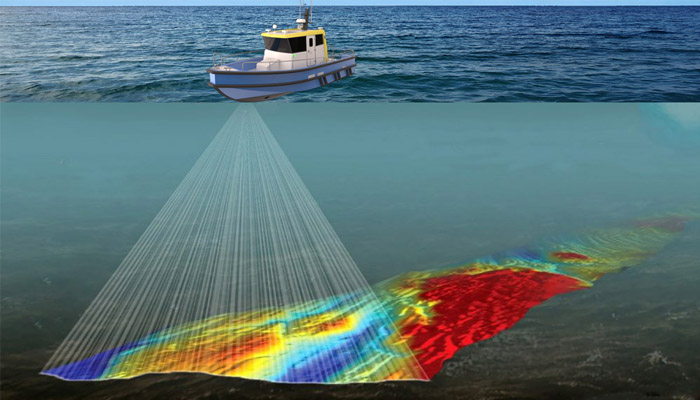
We conduct Bathymetric surveys using an echo sounder attached to a survey boat. As the boat moves across the water, the echo sounder will generate electrical signals. These are then converted into soundwaves by an under-water transducer. Soundwaves will bounce off features under the water and this echo is then identified by the echo sounder. We calculate the distance to the identified feature. In addition, bathymetric survey systems rely on highly accurate GNSS (GPS) systems. This allows them to link each measured distance to a particular depth on the surveying map. Ultimately, data from Marine Geo Survey instrumentation supports precise mapping.
The information gathered from a bathymetric survey is crucial for various applications such as UXO identification, navigation, resource exploration, ecosystem monitoring, and coastal zone management. Therefore, Marine Geo Survey data is essential for informed marine decision making.
3D Seismic Surveys
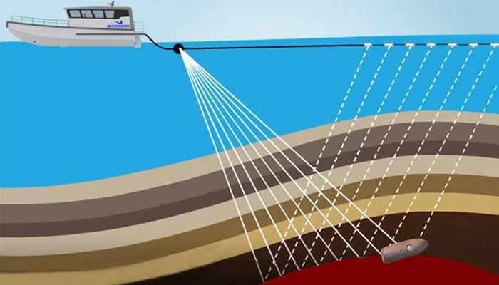
A 3D seismic survey creates detailed images of underground rock formations. It involves sending sound waves into the ground and recording the reflections that bounce back. In the broader context of Survey techniques, 3D seismic data supports deep subsurface analysis.
By using multiple seismic sources and receivers in a grid pattern, we generate a three-dimensional picture of the subsurface geology. Many Marine Geo Survey teams rely on seismic surveys for gathering high-resolution data.
This data can help identify pUXO targets for further investigation. Or within the Oil and Gas industry, it helps geoscientists and engineers locate potential hydrocarbon reservoirs. It also helps plan drilling operations more effectively. Marine Geo Survey findings are critical for these sectors.
Magnetic total field and gradiometer surveys
A magnetic total field and gradiometer survey is a geophysical method used to measure variations in the Earth’s magnetic field. This type of measurement is an important aspect of any complete Marine Geo Survey carried out for exploration.
Total field magnetometers measure the strength and direction of the magnetic field at a specific location, while gradiometers measure the rate of change of the magnetic field over distance. By collecting data from multiple points, these surveys can help identify subsurface features. For example, they may find pUXO targets, buried structures, mineral deposits, or archaeological artifacts that may cause anomalies in the magnetic field. Marine Geo Survey services often include magnetic techniques for comprehensive exploration.
👉CONTACT US NOW – For more information
👉To keep in the loop with all the latest News follow DWI on LinkedIn